|
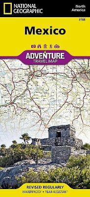
Mexico: Travel Maps International Adventure Map
Sheet map, folded
Main Details
| Title |
Mexico: Travel Maps International Adventure Map
|
| Authors and Contributors |
By (author) National Geographic Maps
|
| Physical Properties |
| Format:Sheet map, folded | | Pages:1 | | Dimensions(mm): Height 235,Width 108 |
|
| Category/Genre | Travel maps and atlases |
|---|
| ISBN/Barcode |
9781566955270
|
| Audience | |
|---|
|
Publishing Details |
| Publisher |
National Geographic Maps
|
| Imprint |
National Geographic Maps
|
| Publication Date |
21 December 2010 |
| Publication Country |
United States
|
Description
AdventureMaps provide global travellers with the perfect combination of detail and perspective, highlighting hundreds of points of interest and the diverse and unique destinations within the country. Each map is printed on durable synthetic paper, making them waterproof and tear-resistant. The north side of the map details from the U.S. Border south to Aguascalientes, including Baja California, Chihuahua, Tijuana, Mazatlan, and Monterrey. The south side covers major Mexican cities, such as Acapulco and Cancun, plus Belize and nearly all of Guatemala at the same scale.
Author Biography
Founded in 1915 as the Cartographic Group, the first division of the National Geographic Society, National Geographic Maps has been responsible for illustrating the world around us through the art and science of mapmaking. Today, National Geographic Maps continues this mission by creating the world's best wall maps, recreation maps, atlases, and globes which inspire people to care about and explore their world. All proceeds from the sale of National Geographic maps go to support the Society's non-profit mission to increase global understanding and promote conservation of our planet through exploration, research, and education.
|