|
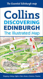
Discovering Edinburgh Illustrated Map
Sheet map, folded
Main Details
| Title |
Discovering Edinburgh Illustrated Map
|
| Authors and Contributors |
By (author) Dominic Beddow
|
|
By (author) Collins Maps
|
| Physical Properties |
| Format:Sheet map, folded | | Dimensions(mm): Height 205,Width 113 |
|
| ISBN/Barcode |
9780008136635
|
| Classifications | Dewey:912.4134 |
|---|
| Audience | |
|---|
| Edition |
New edition
|
| Illustrations |
Illustrations, unspecified
|
|
Publishing Details |
| Publisher |
HarperCollins Publishers
|
| Imprint |
Collins
|
| Publication Date |
7 April 2016 |
| Publication Country |
United Kingdom
|
Description
Edinburgh, home to the Scottish Parliament, is on the itinerary of many visitors to Scotland. Delightful water-colour mapping, with individual paintings of all the main sights and landmarks. Popular areas at larger scale, hundreds of shops, restaurants, cafes and bars, comprehensive travel information and index. This map includes: * Large-scale plans of the Castle, Royal Mile, Botanic Gardens, Leith and Newington * Shop-by-shop street maps of Princes Street, George Street, Victoria Street and the Grassmarket * Railway stations, bus routes, taxi ranks and car parks * Historical and contemporary anecdotes * Suggestions for day trips out of the city * Comprehensive index Area covered: Covers the centre of Edinburgh from Inverleith Park in the north to The Meadows in the south, and from the Scottish National Gallery of Modern Art in the west to the Palace of Holyroodhouse in the east.
Author Biography
Explore the world through accurate and up-to-date mapping.
Reviews"a wonderful picture of what the city has to offer. It is full of intriguing locations and is as much a delight to read as it is to use." Alexander McCall Smith
|


